Quadricentennial Challenge | |
Catskills Live! Trails & Wilderness Association issues a challenge to all — venture forth and seek all 15 Quadricentennial Challenge geocaches. Go to many great places throughout Ulster County — visit the shores of the Hudson, feel the cool air in an historic cement mine, enjoy our small parks, bicycle on our rail trails, summit two Catskill peaks, and savor the breath-taking view from Gertrude's Nose in Minnewaska State Park Preserve. Bask in our county's treasures with family and friends, exercise your body, and build lasting memories. Specially minted commemorative Quadricentennial geocoins are being released from Challenge geocaches in celebration of the 400th anniversary of the exploration of New York State by Henry Hudson. All 15 Challenge caches will be available this summer. Funding for the Challenge was provided by Ulster County and the Hudson River Valley Greenway. |  |
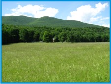
| High Point Mountain | |
 | At 3080 feet above mean sea level (3080 ft. msl), High Point Mountain is the 83rd highest peak in the New York State Catskill Forest Preserve. It is 1100 feet lower than Slide Mountain, the highest peak in the Catskills. |
Sometimes referred to as Ashokan High Point Mountain, High Point Mountain stands prominently out from other mountains situated further to the north, northwest, and west. For this reason, it was considered for a mountaintop hotel in the 1800s. Its lofty heights provide excellent views of the region, especially during leaf-off conditions. | 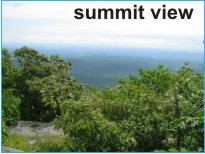 |
The elevation gain from Kanape Brook, near the parking area, to the summit is about 1,980 feet and is strenuous in places, but mostly only near the top of the mountain. This moderately strenuous route with the summit trail loop is about an 8 mile round trip. | 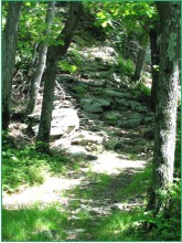 |
 | This is a most pleasant Catskill Mountain hike. |
Glacial Lake Shandaken and Wagon Wheel Gap | |
 | The forested and sculpted landscape you hike up through on the way to the summit is the product of hundreds of thousands of years of erosion by streams and glaciers. |
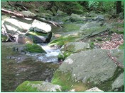
Today, the waters of Kanape Brook (followed along the lower trail) slowly wind their way down hill, first joining the Bush Kill, and then flowing into the Ashokan Reservoir, which is actually the dammed up Esopus Creek (at 585 ft. msl). While the 12-mile long Ashokan Reservoir seems large by today's standards, it would have been dwarfed by the glacial lakes once present there. | 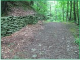 |
 | About 14,000 years ago, the waters of the Esopus Creek were impounded in an expansive glacial lake behind a huge ice dam that extended between Overlook and High Point Mountains, as well as far to the north and south. NYS Quad Challenge - Tremper Mountain (GC1V6F3) discusses Glacial Lake Peekamoose that drained out the Peekamoose gap at 1830 ft. msl. |
As this massive ice dam pressed against the east side of High Point Mountain began to melt down, it eventually decreased in height until another lower outlet elevation was reached. This occurred along the flank of High Point Mountain. When the surface elevation of the glacial dam dropped to about 1600 ft. msl, the water level of Glacial Lake Peekamoose rapidly dropped in response to a lower release point. It quickly cut a V-notched water-gap in the side of High Point Mountain where a bedrock-walled gorge now roared with surging glacial melt waters. This gap, located about 2/3 of the distance down the flank of the mountain, is referred to by geologists as the Wagon Wheel Gap. One good observation point is from the Ashokan Reservoir Dividing Weir along Reservoir Road, especially during leaf-off conditions. |  |
 As this narrow gorge was down cut, the glacial lake level fell first from 1830 ft., to about 1600 feet, and then downward to about 1330 feet. This new lake is referred to as Glacial Lake Shandaken. Clues documenting the presence of this glacial lake are found in sediments in the Esopus Creek watershed, in the now dry relict plunge pools and water falls on the east side of High Point Mountain, and in the form of water gap itself. As this narrow gorge was down cut, the glacial lake level fell first from 1830 ft., to about 1600 feet, and then downward to about 1330 feet. This new lake is referred to as Glacial Lake Shandaken. Clues documenting the presence of this glacial lake are found in sediments in the Esopus Creek watershed, in the now dry relict plunge pools and water falls on the east side of High Point Mountain, and in the form of water gap itself. | |
 As you climb the mountain, picture yourself first crossing Kanape Brook at about 1100 ft. msl on the bottom of a vast glacial lake, some 730 feet and 230 feet beneath the surfaces of Glacial Lakes Peekamoose and Shandaken, respectively. The maximum depths of these glacial lakes were about 1435 and 935 feet near the Ashokan Reservoir. Then picture yourself ascending through the surface of Glacial Lake Shandaken, upward another 1750 feet to the summit amidst the thundering roar of melt water and icebergs cascading through nearby Wagon Wheel Gap. Glacial melt water from the Esopus and other streams have, through time, helped carve and deepen the Hudson River so that it was navigable by Henry Hudson and as it continues to this day. As you climb the mountain, picture yourself first crossing Kanape Brook at about 1100 ft. msl on the bottom of a vast glacial lake, some 730 feet and 230 feet beneath the surfaces of Glacial Lakes Peekamoose and Shandaken, respectively. The maximum depths of these glacial lakes were about 1435 and 935 feet near the Ashokan Reservoir. Then picture yourself ascending through the surface of Glacial Lake Shandaken, upward another 1750 feet to the summit amidst the thundering roar of melt water and icebergs cascading through nearby Wagon Wheel Gap. Glacial melt water from the Esopus and other streams have, through time, helped carve and deepen the Hudson River so that it was navigable by Henry Hudson and as it continues to this day. | |
The Mountainside Today | |
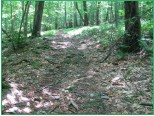
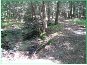
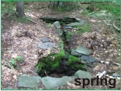
Kanape Brook is crossed and followed in the early stages of this hike. Vestiges of previous settlement are seen in a laid stone spring, stone walls, stone piles, and the remains of an old dam now only partially across Kanape Brook. | 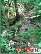 |
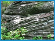 | A large portion of the trail is quite gentle and is used for crosscountry skiing. In places, sandstone ledges with cross-bedded layers whisper of deposition in braided stream channels almost 400 million years ago. |
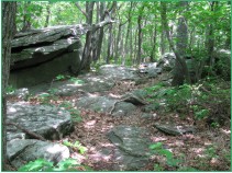
 | Closer to the summit, steep trail sections are generally short in nature, followed by more gentle trail segments. It is by far the better plan to complete the upper trail loop in a counter-clockwise direction, thereby continuing straight at the loop junction point. Also, this direction is preferable relative to both the ease of ascending and descending from the mountain's summit. |
While more scenic vantage points are present during times of leaf-off, a number of excellent vistas are present year round — especially the summit vista. The broad summit area itself is well worth the hike, as dwarf oaks and expansive blueberry meadows will bring a smile to all. Be sure to stay on the trail and protect this area. | 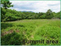 |
| | |
The Cache and Parking Access | |
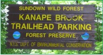 | Access to the cache is from Route 42, the Peekamoose Road, found extending westward from Route 28A out of West Shokan. An established parking area is present along the northwest side of Route 42. The parking area and trail are illustrated on NY-NJ Trail Conference Map 43 of southern Catskill Trails. The trail begins on the opposite side of the road from the parking area. |
| | |
The cache is a 2-liter cylindrical poly bottle hidden a short distance from the trail. It is not located on the summit of the mountain, but rather down slope and west of the summit at an elevation of about 2810 ft. msl. The cache is best approached by following the upper loop portion of the trail in a counter-clockwise direction, continuing past the summit and beyond. |  |
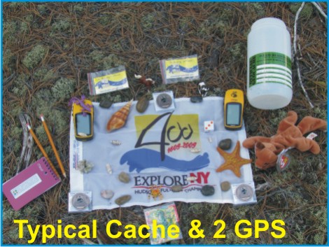 | The cache is filled with kid-friendly items and, initially, four NYS Quadricentennial Challenge geocoins designed to travel throughout the world. This geocache was approved by the New York State Department of Environmental Conservation. |
| | |
Please Cache In and Trash Out! | |