Quadricentennial Challenge
John Burroughs Sanctuary
 Today, we recognize John Burroughs for his deep appreciation of natural history that has, in turn, led others to protect some of our nation's most cherished lands. Burroughs spent time in this sanctuary and the surrounding area from 1873 until his death in 1921. You may sense his presence as you enjoy these preserved lands that are the landscape of his essays.
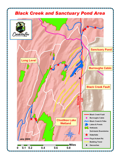
This is a true paradise for naturalists. Black Creek Fault, Deformed Bedrock & Wetlands
 Time and nature are a powerful team. The rugged character of the area and rich species diversity resulted from a combination of folding and faulting of the bedrock, natural stream erosion, and rock removal by glaciers. This portion of the Hudson Valley is known by geologists because of its many faults. For observant geocachers, there are many geologic clues that tell the tale of the sculpted landscape — small and large.
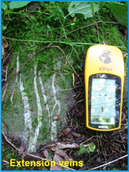
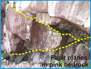
Look, for example, at the lightning-like pattern in the bedrock some 25 feet from the steps of John Burroughs' Slabsides cottage retreat he built in 1895. These extension veins are evidence of nearby faulting. As seen on the map above, Burroughs spent considerable time nearly on top of a huge fault! 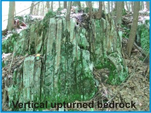 It is this same Black Creek Fault that serves to contain water in the northeastern end of his beloved Sanctuary Pond. The linear trend of this fault and deformed rock layers are readily visible on satellite imagery. Eons ago, rock layers east of the fault line were thrust up vertically from their original horizontal position. These layers now act as a natural dam. Other clear signs of faulting and folding can be seen in geologic rock layers that are upturned at various angles, ranging from a few degrees to vertical. The map above, which is based on field mapping and aerial photography, shows how bedrock layers curve into and abruptly end in the Black Creek Fault. You can walk across this massive fault line near the northern tip of Sanctuary Pond, about 35 feet north of the Alfred Adams Connecting Trail and 125 feet from Sanctuary Pond.
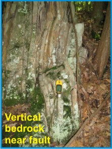 Most of the bedrock layers between the Slabsides cabin and Sanctuary Pond slope downward to the southeast between 15 and 36 degrees from horizontal. However, at and just west of the Black Creek Fault, rock layers are drag folded and upturned steeply toward vertical. Look for this change. With practice, some geologists think they can feel faint vibrations when they cross fault lines. Can you?
Flora and Fauna
NYS Quad Challenge Geocache - Burroughs' Natural Refrigerator 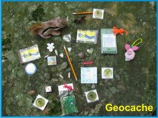 This geocache is strategically placed in a small, cool, natural cave that was used by John Burroughs to store butter and other perishables — nature's refrigerator. While Burroughs used a wooden ladder to descend into this cave, it is easily accessed by scrambling down rocks behind his Slabsides cabin. A flashlight is not needed. Joan Burroughs selected this cache location to help preserve knowledge of her great grandfather's daily life.
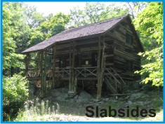
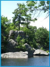
It is likely that Burroughs constructed a wooden door or covered rock storage cache here to secure his food from animals. The geocache is a 2-liter cylindrical poly bottle hidden where access does not necessitate damaging vegetation. The cache is filled with kid-friendly items and, initially, four NYS Quadricentennial Challenge geocoins designed to travel throughout the world. This geocache location was selected and approved by The John Burroughs Association. Nearby Wake Robin Geocache 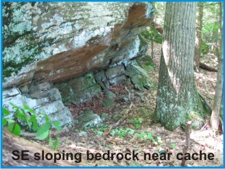 Another excellent geocache, though currently rogue (not yet formally permitted), is present in the John Burroughs Sanctuary along the Elizabeth Burroughs Kelley Connector Trail that connects the Slabsides cabin and Sanctuary Pond. The Wake Robin geocache (GC135YP) was placed on May 26, 2007 and has, to date, been visited by more than 30 geocachers. Their logged comments, much like the guest book names of many of Burroughs' visitors (e.g., Theodore Roosevelt, Muir, Edison, Ford), show their appreciation for being introduced to this beautiful, historic, sanctuary steeped in nature. The Wake Robin cache is sited in a habitat-friendly location some 150 feet southwest of a relict laid stone catchment dam and pond. What do you think this structure was used for? The adjacent photo (labeled Southeast sloping bedrock near cache) depicts multiple bedrock layers like those seen sloping at 23 degrees to the southeast near the Wake Robin geocache. Most of Sanctuary Pond lies above similarly sloping bedrock layers.
Parking Small parking areas are present along Floyd Ackert Road and near the entry gate on Burroughs Drive. The John Burroughs Sanctuary is open from dawn to dusk. Please Cache In and Trash Out! |
 Catskills Live! Trails & Wilderness Association issues a challenge to all —
venture forth and seek all 15 Quadricentennial Challenge geocaches. Go to many great places
throughout Ulster County — visit the shores of the Hudson, feel the cool air in an historic
cement mine, enjoy our small parks, ride on our rail trails, summit two Catskill peaks, and savor
the breath-taking view from Gertrude's Nose in Minnewaska State Park Preserve. Bask in our county's
treasures with family and friends, exercise your body, and build lasting memories. Specially minted
commemorative Quadricentennial geocoins are being released from Challenge geocaches in celebration of
the 400th anniversary of the exploration of New York State by Henry Hudson. All 15 Challenge caches will be available this summer. Funding for the Challenge was provided by Ulster
County and the Hudson River Valley Greenway.
Catskills Live! Trails & Wilderness Association issues a challenge to all —
venture forth and seek all 15 Quadricentennial Challenge geocaches. Go to many great places
throughout Ulster County — visit the shores of the Hudson, feel the cool air in an historic
cement mine, enjoy our small parks, ride on our rail trails, summit two Catskill peaks, and savor
the breath-taking view from Gertrude's Nose in Minnewaska State Park Preserve. Bask in our county's
treasures with family and friends, exercise your body, and build lasting memories. Specially minted
commemorative Quadricentennial geocoins are being released from Challenge geocaches in celebration of
the 400th anniversary of the exploration of New York State by Henry Hudson. All 15 Challenge caches will be available this summer. Funding for the Challenge was provided by Ulster
County and the Hudson River Valley Greenway.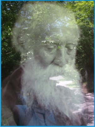 While separated in time by hundreds of years, John Burroughs and Henry Hudson both opened up important new frontiers in the Hudson Valley that ultimately extended throughout the world and shaped our society. Henry Hudson opened the Hudson Valley to exploration, homesteading, and eventually exploitation. Famed naturalist John Burroughs taught us the importance of observing, studying, and preserving nature.
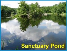 Spend some time in and around the 196-acre John Burroughs Sanctuary and you will come to appreciate the rugged, pristine, beauty of nature that Burroughs loved and wrote about.
 An important second factor serves to keep much of the Sanctuary Pond water within the pond — southeast sloping bedrock layers situated west of the Black Creek fault. Excellent examples of this sloping bedrock may be seen on the northwest facing side of the peninsula jutting into Sanctuary Pond and at the Wake Robin geocache placement.
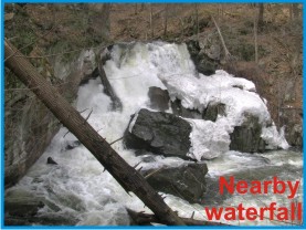
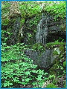
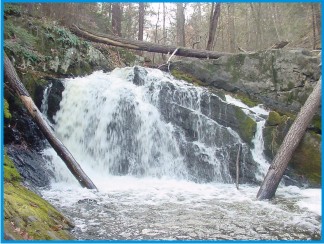 Two of the waterfalls situated along the Black Creek and a short distance upstream of Slabsides once had thriving grist mills. It is easy to envision John Burroughs reveling and sharing in the wild beauty of his surroundings. We are fortunate today that The John Burroughs Association and Scenic Hudson have worked to preserve much of this Black Creek land just as it was long ago. The two waterfalls depicted are north of Floyd Ackert Road and are not within the John Burroughs Sanctuary. Bedrock at these falls is comprised of the beautiful pink sandstone and conglomerates of the Shaupeneak Formation.
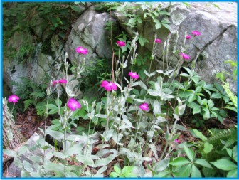
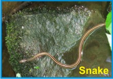
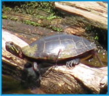 The John Burroughs Sanctuary teams with flora and fauna throughout forest lands, wetlands, on rocky ledges, in streams, and in Sanctuary Pond. Picture the pleasant sight of beavers slapping their tails on Sanctuary Pond shrouded in early morning mist.