Quadricentennial Challenge | |
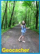 Catskills Live! Trails & Wilderness Association issues a challenge to all — venture forth and seek all 15 Quadricentennial Challenge geocaches. Go to many great places throughout Ulster County — visit the shores of the Hudson, feel the cool air in an historic cement mine, enjoy our small parks, ride on our rail trails, summit two Catskill peaks, and savor the breath-taking view from Gertrude's Nose in Minnewaska State Park Preserve. Bask in our county's treasures with family and friends, exercise your body, and build lasting memories. Specially minted commemorative Quadricentennial geocoins are being released from Challenge geocaches in celebration of
the 400th anniversary of the exploration of New York State by Henry Hudson. All 15 Challenge caches will be available this summer. Funding for the Challenge was provided by Ulster County and the Hudson River Valley Greenway. | |
Rondout Creek | |
The Rochester Canal and Rail Trail Park is situated along a short segment of the northeastward flowing Rondout Creek. This creek played an important early role in the industrialization, development, and settlement of the region. The Rondout Creek upstream of a U.S. Geological Survey gauging station in nearby Rosendale receives its water from a 383 square mile watershed that extends, in part, far up into the Catskill Mountains. As a result, large snowmelt and rain events cause the creek level to rise rapidly, often turning the water a muddy clay-brown color. | 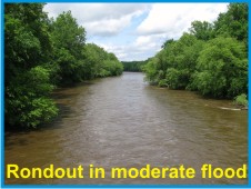 |
| | |
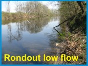 Historic records show that the amount of water flowing in the creek has ranged from a low of 3.0 cubic feet per second (cfs) on July 16, 1965 to a high of about 35,800 cfs on October 16, 1955. At the 1955 peak flow rate, the Rondout Creek could have filled 24 Olympic sized swimming pools (50m x 25m x 2m) every minute. A short distance downstream, the Rondout Creek is joined by the Wallkill River, effectively tripling the watershed area. It is no wonder that families purchasing newly approved and constructed housing in the floodplains of these mighty rivers place their homes, themselves, and their families at great personal risk. It is, however, the harnessed power of the Rondout Creek that has played a vital role in our country's historical development. | |
Early Industrialization Near the Rochester Rail Trail | |
|
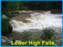
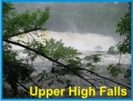
Following in the footsteps of Henry Hudson's opening of the expansive Hudson River watershed, the Rondout Creek became poised as a critical trade and market link in the early industrialization of the region. The Rondout Creek and its Wallkill River tributary flow into the Hudson River at Eddyville, a short distance south of Kingston, New York. Just downstream of the Rochester Rail Trail in High Falls, the upper and lower falls were the former sites of mills constructed after 1783 and by 1796, respectively. |
| | |
Mills were first used for washing and felting of woolen cloth, to cut lumber, to grind grain and, later, with the growing Rosendale cement industry to grind cement. In High Falls and elsewhere, you may have seen the beautiful, round, white quartzite grindstones used in the milling process. They are made of the Shawangunk Conglomerate, the same resistant rock climbers scale in New Paltz and Gardiner. |

|
| | |
|
Water power in High Falls was also used to run factories, a tannery, and a cooperage. Today, the water power is harnessed for generating electricity. |
| | |
|
A Walk Through Historic Time |
|
The Rochester Rail Trail follows part of the historic route of the Delaware and Hudson (D&H) Canal. D&H Canal construction was started in 1825 and completed in 1828 using the nearby Rosendale hydraulic cement as mortar (see NYS Quad Challenge - Widow Jane Mine for additional details). The early canal itself was typically thirty feet wide with a maximum water depth of four feet. |
|
| | |
The D & H Canal linked Honedale, Pennsylvania, the Rondout Creek, and the Hudson River near Kingston, New York. This was the third major canal to be completed in the United States. While the 108-mile long, hand-dug, channel was constructed to transport coal to New York City, it soon became a major transport route for Rosendale cement and other marketable items as well. | |
| | |
Towns, including High Falls, blossomed at locks along the canal. In many places, the rounded hollow alongside the rail bed is the former canal channel. |
|
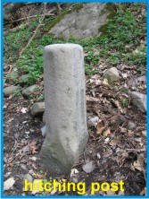
Imagine young boys along the tow path leading mules pulling 20-ton barges in the water-filled canal. Between 1842 and 1852, the canal was enlarged and deepened three times to allow 40 ton, 50 ton, and even 130 ton barges to move through six feet of water. Near the northern end of the rail trail a well-worn hitching or snubbing post may be touched. |
|
|
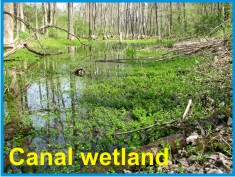
The canal closed at the end of the century, giving way to the railway by about 1901, a portion of which is now the bed of The Rochester Rail Trail. In places, the railroad used portions of the canal bed for their tracks and in others, the canal channel was left undisturbed. |
| | |
|
Assorted wetland animal and plant species now thrive in remnants of the old canal bed. |
| | |
|
Trail Tidbits |
|
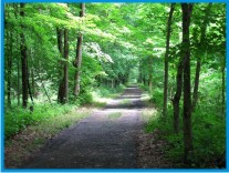
This 3.5 mile long scenic trail is uninterrupted by road crossings throughout its length, making it excellent for bicycling, walking, and jogging. Its gentle grade is perfectly suited for both children and adults and frequently provides views of the Rondout Creek and relict segments of the historic canal channel. |
|
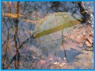
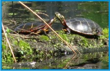
| If you're lucky, you'll see a large snapping turtle in abandoned segments of the canal channel. |
| At the small stream crossing just south of the Picnic Area (near the cache), look down at the red High Falls Shale. This is an excellent exposure of a local rock formation that is not normally seen because of its soft, weak, nature. As a result, it is commonly a slope formerly covered with vegetation. | 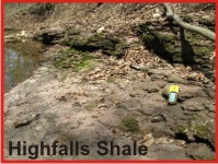
|
| | |
The Cache and Parking Access | |
| | |
|
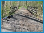
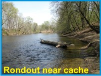
The cache is located along the Rochester Rail Trail relatively close to a scenic Town picnic area overlooking the Rondout Creek. While it is readily accessible from either end of the Rail Trail, it is closest to the Berme Road trailhead parking area - some 0.66 miles distant. |
| | |
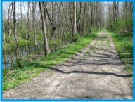
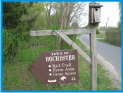
It is also accessible from the trail's northern terminus, close to a parking area near the Kerhonkson Fire House. Access from this end of the Rail Trail soon passes alongside a wetland teaming with birds, turtles, and other wildlife. Access is also readily available at the northern terminus of the trail, next to a small playground at the Rochester Town Park, near Town offices. |
|
|
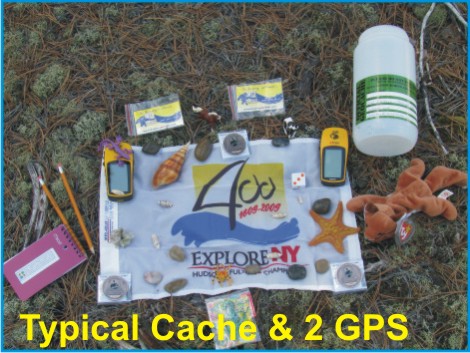
The cache is a 2-liter cylindrical poly bottle and is filled with kid-friendly items and, initially, four NYS Quadricentennial Challenge geocoins designed to travel throughout the world. This geocache was approved by the Town of Rochester Supervisor. |
| | |
Please Cache In and Trash Out! | |