|
Quadricentennial Challenge
Catskills Live! Trails & Wilderness Association issues a challenge to all — venture forth and seek all 15 Quadricentennial Challenge geocaches. Go to many great places throughout Ulster County — visit the shores of the Hudson, feel the cool air in an historic cement mine, enjoy our small parks, ride on our rail trails, summit two Catskill peaks, and savor the breath-taking view from Gertrude's Nose in Minnewaska State Park Preserve. Bask in our county's treasures with family and friends, exercise your body, and build lasting memories. Specially minted commemorative Quadricentennial geocoins are being released from Challenge geocaches in celebration of the 400th anniversary of the exploration of the Hudson by Henry Hudson. All 15 Challenge caches will be available this summer. Funding for the Challenge was provided by Ulster County and the Hudson River Valley Greenway.
Tremper Mountain
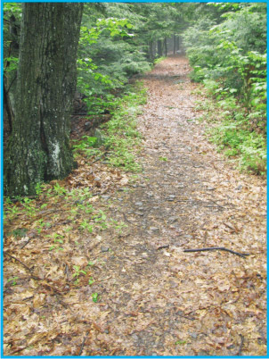
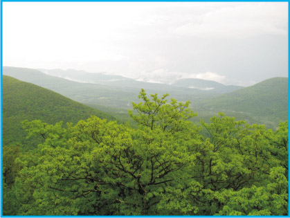
 At 2740 feet above mean sea level, Tremper Mountain is one of the lower peaks in the New York State Catskill Forest Preserve. Much of the hike up from the Old Route 28 parking area follows the Phoenicia Trail, initially as a rocky, wide, unpaved road. After a while, the roadway turns into a pleasant trail.
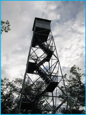
The elevation gain to the summit is about 2,000 feet and is strenuous in places. A fire tower at the top affords excellent views of surrounding mountains and valleys, including the Burroughs Range, Ashokan Reservoir, Mount Tobias, and Black Dome Mountain, making the 3-mile hike up well worth while. Alternately, the summit may be approached from the end of Jessup Road in Willow. This moderately strenuous route is about 8 miles round trip, but gains only 1640 feet over a longer distance than from Old Route 28.
A Trek Back in Recent Geologic Time
The forested and sculpted landscape you hike up through is the product of hundreds of thousands of years of erosion by streams and glaciers. The waters of the Esopus Creek at the base of this hike have flowed to the Hudson River through the eons, helping to deepen it for exploration by Henry Hudson and others.
 Have you ever wondered what it would be like to hike along the bottom of a lake? Near the end of the most recent glaciation, a huge glacial ice wall blocked the outlet of the Esopus Creek in the vicinity of the Ashokan Reservoir. This high ice dam was part of a massive valley glacier that extended between Overlook and High Point Mountains and beyond, effectively blocking pre-glacial Esopus Creek drainage. This resulted in different levels of glacial lakes being impounded behind this ice dam, changing as the ice sheet melted. Two of the former glacial lake levels reflect former outlet elevations that may be visited today. Glacial Lake Shandaken, at 1330 feet msl, will be discussed in NYS Quad Challenge - High Point Mountain. The oldest recognized glacial lake level was at 1830 feet msl — Glacial Lake Peekamoose. This lake drained westward through the Peekamoose gap and was backed up throughout the main stem of the Esopus Creek and many of its tributary valleys, including the Stony Clove and Beaver Kill valleys.
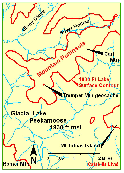
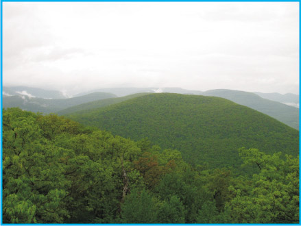
 Imagine as you hike up from the Esopus Creek that you are climbing upward through almost 1,100 feet of ice cold water. You break the water surface at 1830 feet msl and proceed upward another 910 feet to the treeless summit of Tremper Mountain. Your view would have been of an expansive glacial lake with distant mountain peaks. You can see on the map that you would have been on a rocky elongate peninsula that came close to being an island. By comparison, this glacial lake would have dwarfed the relatively small Ashokan Reservoir that we see today. It is likely that icebergs floated in the lake, having broken off from melting mountain glaciers. Relict steep-walled cirques in the Stony Clove – Edgewood area whisper of these bygone glaciers. Other sediments in nearby Edgewood speak of another massive ice wall pressed against the Stony Clove notch. As you stand on the northwestern tip of the peninsula, listen and look northeast across the lake surface into the notch to see meltwaters from this glacier thundering through the notch only briefly until flowing into Glacial Lake Peekamoose. This was an exciting time some 14,000 years ago.
Before you head back down the trail, be sure to notice skull-shaped Mount Tobias Island to the southeast, projecting some 720 feet above the surface of Glacial Lake Peekamoose. The little island to the west of Mount Tobias Island measured 1,380 feet long by 720 feet wide. It projected 80 feet above the surface of Glacial Lake Peekamoose.
The Mountainside Today
 The Esopus Creek is near the base of this trail. If you take a close look in the creek bottom, you may see soft, finely-layered clays that were deposited year-after-year in Glacial Lake Peekamoose. Floodwaters regularly lift cobbles and boulders from the creek bottom and suspend these clays in chocolate-milk appearing water, thus resulting in a water quality problem for New York City.
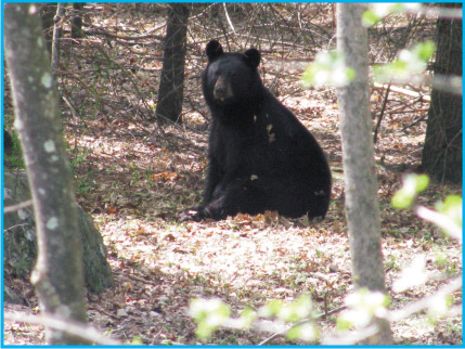 Lots of rocky ledges are seen along the trail on the way up. If you're lucky you might see a black bear as it disappears into the forest.
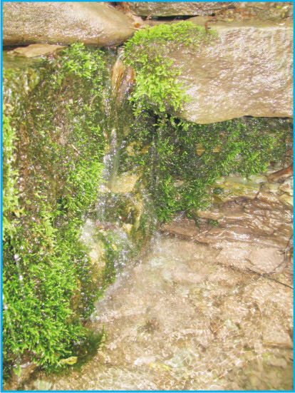
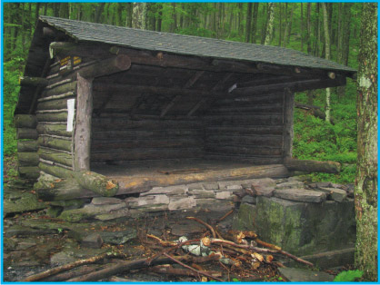
Two lean-tos are available for camping for those who wish to enjoy a night out. Look closely at the photograph of a trailside spring. This is typical of Catskill Mountain springs where water flows downward through vertical fractures in sandstone bedrock, only to surface along the hillslope when an underlying shale bed is encountered.
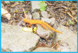
 Animals seen or heard when setting this cache up included a red eft, a brown creeper, a great horned owl, juncos, a cat bird, and a black bear. Rattlesnakes have been reported on Tremper Mountain.
The fire tower may be climbed for views, but the top portion is locked.
The Cache
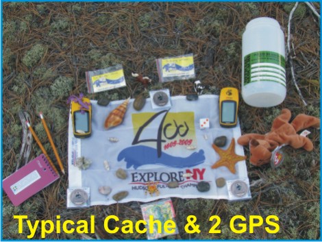 Access to the cache is from Old Route 28 or from the end of Jessup Road in Willow. An established parking area is present along Old Route 28. Parking permission needs to be requested along Jessup Road. Northeastern Catskill Trails Map 41 published by the NY-NJ Trail Conference is recommended. The cache is a 2-liter cylindrical poly bottle hidden along the trail a short distance from the fire tower. The cache is filled with kid-friendly items and, initially, three NYS Quadricentennial Challenge geocoins designed to travel throughout the world.
This geocache was approved by the New York State Department of Environmental Conservation.
Parking
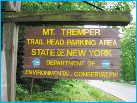 Public parking is available along Old Route 28 (County Route 40; also know as The Plank Road) at the edge of the hamlet of Phoenicia in the Town of Shandaken.
Please Cache In and Trash Out!
|